Now
21st century
copied from: http://www.lisser.us/Final_Draft_HTML/Tech_Report_HTM/PDFs/Chap4/PART2D.pdf
Part Two: Maritime Centers of the South Shore Estuary Reserve 2-69
SHINNECOCK CANAL33
The Shinnecock Canal (see photo 19 and map 23) is just east of the Hamlet of Hampton Bays in the Town of Southampton and Suffolk County. The canal and the water dependent businesses and facilities on both sides of the canal constitute a major maritime center of the South Shore Estuary Reserve. The maritime center is considered a ``significant cultural maritime place'' for purposes of the SSER Comprehensive Management Plan.
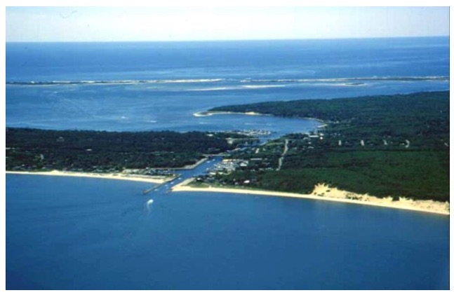
Photo 19: Shinnecock Canal maritime center (crossed by Sunrise and Montauk highways) looking east; Great Peconic Bay to left and Shinnecock Bay to right.
Construction of the canal was completed in 1892 to facilitate navigation and help revitalize fishing and shellfishing industries. It provides an almost one mile long navigable connection between Great Peconic Bay to the north and Shinnecock Bay to the south. Boaters from Long Island Sound and Great Peconic Bay may enter Shinnecock Bay and the South Shore Estuary via the Shinnecock Canal and then follow the Federal Long Island Intracoastal Waterway Channel westward through Moriches Bay to Great South Bay. The Intracoastal Waterway Channel begins at the south end of the canal.
33
Much of the information on existing conditions in the Shinnecock Canal maritime center presented in this section is taken from the draft report ``Zoning for Water Dependent Uses: Case Studies of Four South Shore Estuary Reserve Maritime Centers (Water Dependent Zoning Report),'' March 1999, by Geoffrey Steadman.
2-70 Maritime Centers Report for the SSER Comprehensive Management Plan
Part Two: Maritime Centers of the South Shore Estuary Reserve 2-71
Navigational locks were installed in 1919 to aid the passage of boats on the canal and to control water and salinity levels, thereby improving fisheries resources in Shinnecock Bay which at that time had no other physical connection with the Atlantic Ocean. (It was not until 1938 that the great hurricane of that year opened the Shinnecock Inlet connecting the Bay with the Atlantic Ocean.) The flow of water in the canal is controlled so that water flows only in one direction—from Great Peconic Bay to Shinnecock Bay. The lock system is owned and operated by Suffolk County, and is Long Island's only operating navigational lock system.
The Shinnecock Canal area supports the largest concentration of water dependent uses in the Town of Southampton and is the principal opportunity area for expansion of those uses in the Town. Representatives of the Town's Department of Land Management say that due to the presence of wetlands and other sensitive resources there are very few sites left in Town that can accommodate new marina development. The water dependent businesses and facilities along the canal are considered extremely important to the economy of the Town which is based largely on tourism. The canal itself is a significant maritime attraction because of its historic and engineering significance.
Research by the Town of Southampton identifies eight marinas providing a total of 821 boat slips in the canal area,34 including the Suffolk County Shinnecock Marina, part of the County's Meschutt Park, which provides some 60 slips for primarily transient boaters. The marinas vary in size and type of boating services provided and are said to cater primarily to medium-size and larger pleasure craft.
The areas near both sides of the canal also include single-family residential communities as well as restaurants and several facilities described as resort waterfront motels. The residential areas are characterized as high density residential communities with very limited opportunities for future growth—either through further subdivision or additional single family home construction. All of the land in the maritime center is privately owned except for Meschutt Park, some upland property associated with the canal's lock system, and transportation right-of-ways. Nearly the entire shoreline of the canal is fortified with concrete retaining walls, bulkheads, and riprap. The maintenance of these structures is considered critical in providing for safe navigation and a functional lock system.
Both sides of the canal are extensively used by local residents for recreational fishing. In particular, Canal Road East and Canal Road West provide direct access to the canal's shoreline and are popular waterfront fishing locations.
Three fixed bridges cross the canal. The northern bridge, about half way along the length of the canal, carries the Sunrise Highway, a four-lane State highway providing access to Long Island's south fork. The middle span supports the tracks of the Long Island Railroad, and the southerly bridge carries the Montauk Highway, a County road serving communities along the south shore of Long Island.
34
See ``Shinnecock Canal Public Access Sites and Maritime Planned Development District Recommended Plan,'' October 1996, by the Town of Southampton Department of Land Management. Also, research by the New York Sea Grant Extension Program (see ``Draft Summary of Recreational Boating Facilities in the South Shore Estuary R e s e r v e , ' ' J u n e 1 9 9 7 , c o m p i l e d b y J a y T a n s k i , N e w Y o r k S e a G r a n t E x t e n s io n P r o g r a m ) i d e n t i fi e s s e v e n r e c re a t i o n a l boating facilities in the canal area, including the Suffolk County Shinnecock Marina, providing a total of 679 boat slips. According to the Sea Grant research, two of the Shinnecock Canal marina facilities provide dry storage space (a total of 98 storage spaces are indicated); five provide fuel; four provide repair services; and four provide boat, motor, and /or trailer sales.
2-72 Maritime Centers Report for the SSER Comprehensive Management Plan
More detailed descriptions of the canal and existing waterfront conditions and facilities along the canal are provided in the ``Shinnecock Canal Public Access Sites and Maritime Planned Development District; Final Recommended Plan,'' and in the Town of Southampton's draft Local Waterfront Revitalization Program.
Waterfront use and development in the Shinnecock Canal maritime center is controlled by the Town of Southampton's zoning regulations. A detailed description of the Town's land use regulations, standards, and procedures affecting waterfront use and development is included in the Water Dependent Zoning Report for the SSER CMP. The most prominent zoning district in the maritime center is the ``Resort and Waterfront Business (RWB)'' district. Other districts include the Open Space Conservation district (applied to Meschutt Park), the Motel Business district, and the R-15 residential district. (See the Water Dependent Zoning Report.)
Also of interest with respect to protecting and promoting water dependent uses in the maritime center is the Town's ``Maritime Planned Development (MPD)'' district. The Town Board may, upon its own motion or written application from the landowner, amend the Zoning Map to apply the MPD district. Representatives of the Department of Land Management describe the MPD district as a ``floating zone'' that would be applied as an ``overlay district'' on top of the underlying zoning if certain conditions are met. The MPD district, they say, is intended to allow for a wider range of uses than the underlying zoning and to encourage waterfront revitalization. This is the only incentive-type zoning district identified in the SSER. The Southampton regulations require that an MPD district may be applied by the Town Board after it is determined that a submitted development plan is ``beneficial, compatible and harmon ious'' with surrounding land uses and maintains and furthers the goals of the Comprehensive Plan and Local Waterfront Revitalization Program.